Cerredolo de' Coppi
Place:
Cerredolo de' Coppi - 42026 Canossa
How to get there:
Location Ceredolo dei Coppi
Distance from administrative capital: about 12 km.
From Ciano d'Enza you take the SP 54 in the direction of Casina up to the sign for the Location
Distance from administrative capital: about 12 km.
From Ciano d'Enza you take the SP 54 in the direction of Casina up to the sign for the Location
Tourist Area:
Tourist Area
Apennines
Apennines
Geographic Area:
Matildic Zone
Analytical text:
Description
The name is connected to the surrounding Turkey oaks woods while the "Coppi" refers to the active brick industry, which was flourishing up to the 19th century thanks to the clay which is abundantly found at the bottom of the hill. The ruins of the fort of the same name, visible on the peak of a hill near the town prove that the place has been inhabitied since medieval times.
Many dwellings denote a relative wealthiness of the hamlet and are generally organized along an inside courtyard closed by the main house, sometimes built near a tower house, and by a boundary wall with an entrance portal.
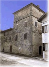
In the suburb entry the powerful 16th century tower house stands out.
A particular feature of the ancient houses' building parameters is the unusual number of "apotropaic projections", a sort of jutting ashlars made by carved in stylized faces shape sandstone.
The whole Canossa area and Val Tassobbio show some examples of those faces, in the Casina commune you can notice them in Bergogno and in Beleo, they probably date back to the 16th-18th centuries, time of stone houses building.
Their meaning is uncertain, maybe of good wishes or of protection, linked to pre-Christian origin superstition, probably from Celtic origin.
On the walls of a lot of other blocks of buildings there are ancient sandstone portal, some of them can be dated to late Middle Ages.
The parish church, located toward west, goes back to the first decades of 20th century.
The name is connected to the surrounding Turkey oaks woods while the "Coppi" refers to the active brick industry, which was flourishing up to the 19th century thanks to the clay which is abundantly found at the bottom of the hill. The ruins of the fort of the same name, visible on the peak of a hill near the town prove that the place has been inhabitied since medieval times.
Many dwellings denote a relative wealthiness of the hamlet and are generally organized along an inside courtyard closed by the main house, sometimes built near a tower house, and by a boundary wall with an entrance portal.
In the suburb entry the powerful 16th century tower house stands out.
A particular feature of the ancient houses' building parameters is the unusual number of "apotropaic projections", a sort of jutting ashlars made by carved in stylized faces shape sandstone.
The whole Canossa area and Val Tassobbio show some examples of those faces, in the Casina commune you can notice them in Bergogno and in Beleo, they probably date back to the 16th-18th centuries, time of stone houses building.
Their meaning is uncertain, maybe of good wishes or of protection, linked to pre-Christian origin superstition, probably from Celtic origin.
On the walls of a lot of other blocks of buildings there are ancient sandstone portal, some of them can be dated to late Middle Ages.
The parish church, located toward west, goes back to the first decades of 20th century.
Useful Links:
Municipality:
CANOSSA
Piazza Matteotti, 28 - loc. Ciano d'Enza, 42026 Canossa (RE)
0522 248411, 0522 248450
urp@comune.canossa.re.it
www.comune.canossa.re.it
Last update: March 5, 2026