Nature Route Valle dei Cavalieri
Place:
Succiso Nuovo - 42032 Ventasso
Contacts:
- 0522 810430 IAT di Castelnovo ne' Monti
- 0522 812313
- iat@appenninoreggiano.it
Periods of Activity:
All year, not advised in winter
The conduct:
The path can be done on foot, on mountain bike, and on horseback.
Organization:
CAI
Route:
It's about 35 km from the administrative capital
Route:
from the administrative capital you take the SP 15 for the Lagastrello Pass, once past the town of Cecciola you take the road on the left for Succiso Nuovo.
Route:
from the administrative capital you take the SP 15 for the Lagastrello Pass, once past the town of Cecciola you take the road on the left for Succiso Nuovo.
Route:
The route starts near Succiso (Villa di Fondo or di Sotto) and ends at Scalucchia Pass.
Tourist Area:
Parco Nazionale dell'Appennino Tosco-emiliano
Geographic Area:
Apennines
Details of tour:
Itinerary in Detail:
The trail is on easily used carriage roads (excursionistic); altitude difference 485 m (1360 - 875 m)
Length 4.5 km (one way)
Walking time (without breaks) 1 hr 30 min.
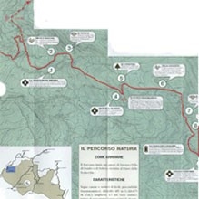
The "Valle die Cavaglieri" Nature route is marked on the excursion chart of the Emilia Romagna Region with the code SP.
The route completely overlaps the CAI path 609. Along the route you encounter other trails:
The Ducati route (SD): From Castagneto it leads to the Lagastrello Pass;
n 667: from the Scalucchia pass it leads to Mt Casarola - Alpe di Succiso or to Lake Calamone - Mt Ventasso
The trail is on easily used carriage roads (excursionistic); altitude difference 485 m (1360 - 875 m)
Length 4.5 km (one way)
Walking time (without breaks) 1 hr 30 min.
The "Valle die Cavaglieri" Nature route is marked on the excursion chart of the Emilia Romagna Region with the code SP.
The route completely overlaps the CAI path 609. Along the route you encounter other trails:
The Ducati route (SD): From Castagneto it leads to the Lagastrello Pass;
n 667: from the Scalucchia pass it leads to Mt Casarola - Alpe di Succiso or to Lake Calamone - Mt Ventasso
Municipality:
VENTASSO
Piazza Primo Maggio, 3, Loc. Cervarezza, 42032 Ventasso (RE)
0522/891911, 0522 891520
info@comune.ventasso.re.it
www.comune.ventasso.re.it
Last update: March 5, 2026